iTopoMaps app for iPhone and iPad
Hikers and climbers can now access real full-resolution USGS topographic 1:24k quads with side-scrolling multi-zoom map capabilities.
In addition, quads can be graphically selected for storage on the device for access where you need it most, away from cellular and WiFi coverage!
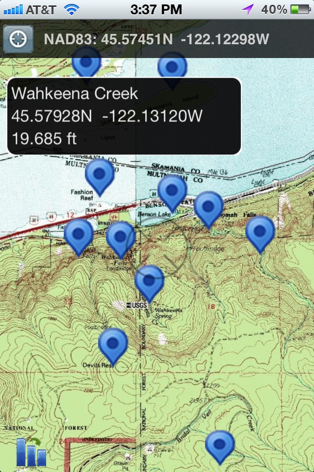
Current Map and GPS positions are available in latitude/longitude and UTM coordinate systems. NAD27 and NAD83 are supported.
Available Map Sources:
USGS (United States and borders)
Toporama (Canada)
OpenCycleMap (World)
OpenStreetMap (World)
11 Zoom Levels are available to give full resolution quadrangles. Simply pinch to zoom in or out! Get in close for details, or zoom out to see your whole area!
Select quadrangles graphically just by double-tapping! No need to mess with coordinates or obscure quadrangle names.
GNIS (Geographic Names Information Service) database included for Features of Interest lookup. Lookup features (summits, waterfalls, streams, etc) and add them as waypoints! No need to type in waypoints by hand. You can also search the database in an area and it will label all local features. ~700k entries available at the touch of a finger!
All 50 United States States included.
Features:
- Full Resolution 1:24k USGS Quads (1:63k in Alaska)
- UTM and latitude/longitude
- Meters and Feet
- NAD27 and NAD83 datums
- Cache maps on your phone!
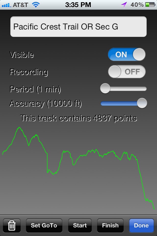
- Display and record Tracks
- Editable Waypoints - Just tap to place or lookup by name.
- Course and Speed
- Bearing / Distance to Waypoints
- Magnetic Declination Calculations
- Map works in portrait and landscape positions!
- GPS Location and Map following
- Look up GNIS locations from geographic formations (like Summits, Streams, Falls, Cliffs, etc) and add them as Waypoints. Have iTopoMaps label neighboring features!
When in Grid Mode, simply double tap an area to select a quad for download! Downloads happen in the background and can be restarted where you left out! Wifi/3G recommended for Quad downloads.
GPS is not required for map usage, but adds to navigation functionality.
New feature requests are always welcome! Join us at http://www.itopomaps.com
Some map data is provided by 3rd parties. Availability and coverage are not guaranteed.
Tags: GPS USGS Topo Topographics Quads Quadrangles WGS WGS84 UTM Waypoints Tracks GNIS Geographic declination
Pros and cons of iTopoMaps app for iPhone and iPad
iTopoMaps app good for
iTopo is a great GPS app. I had to map some proposed trail routes on a ranch recently and brought along the iPad/iTopo as a backup. I checked the first few measurements with my paper quads and handheld GPS and iTopo was in complete agreement After that went with iTopo only. The only slight problem is that battery/electronics would occasionally botch my handheld compass reading. Just dont shoot your bearing with the compass on the screen.
Several years ago, I purchased a Windows based Topo application for north of $100. iTopoMaps is much better than that application was. I particularly appreciate the ability to download quadrants, and that Canadian maps are available. The user interface is a little quirky, but not difficult to learn. I would like to have some basic notation tools that I can apply to downloaded quadrants. The freshness and accuracy of the maps are as good as Ive seen with the Fisher and MacKenzie maps on the market, which is to say they are pretty dated. If youre looking for accurate portages or trail maps, you should still obtain the latest maps from the park.
Works great despite what other reviews say! Very detailed topo maps with nice resolution on iPad. Good buy.
I found the app and the customer service to be pretty good. Ive used the App for a couple of years and without a lot of bells/whistles it simply does what it is supposed to do, show you youre location (within the accuracy limits of Apples GPS) on a topographical map. You can download the quads and if you are taking up too much memory delete the quads youre not using. Had issue with a map and it was fixed in two days -- that said you might want to download your quad couple days before you need it. I wouldnt add features, but would add better FAQs and Help. If youve used a GPS while hiking then this shouldnt be too challenging.
I use this in the Boundary Water Canoe Area in MN. I can pre-download the entire area before going since there is no cell tower reception yet. The GPS overlays on the map since it comes from satellite. The maps show most of the portage points/ routes. You should carry a set of real maps with you as a backup.
My only grip is with the iTunes Store. I somehow got two Apple IDs. I was having problems withe the app, so I trashed and went to download it. I didnt think I would have to purchase it for a second time!
This works great, had to actually read the directions to figure it out how to use it,
It’s not as intuitive as you might think, being a long time Google Earth user, and ESRI ArcMap Tech. I spent 10 minutes frustrated then 2 minutes reading the built in how to use and download maps. My next few hours selecting and downloading the TopoMap for my area of interest and testing OFF-GRID. I am very happy and this and is just what I purchased the iPad for.
Some bad moments
Unfortunately bought this app thinking that would beable to see more topomaps from the world, but is restricted to US. Too bad i spent my money on a lie.
iTopoMaps was a good app, but it is now effectively broken in iOS8 - the map source menu is not populated with options.
Tested with iPhone 6 and an iPad 3, both running iOS 8.0.2 (doesn’t work - no map source). iPhone 4 with iOS 7 still has map source.
Will update review once app is fixed. No contact info or forum on vendor page, so it looks like the company might be asleep or worse ...
User limits are poorly documented. A waste of money. Oh well, live and learn.
Even on a VERY fast wifi connection, trying to load maps made watching paint dry seem like the Indy 500. Clunky...the Topo Maps for iPad app is faster, has more features and even has adjustable raised relief and shading (no I dont work for them...) Its just a better and cheaper alternative to this one.
Im sure this app is good for something. But Im not sure what. I cant get close enough to pick up a trail. Should have read the comments before I paid way too much.
I wait and wait for the base map to appear so I can select a portion, but it never does. Support website is minimal at best. Regrettably, this was a complete waste of money.